
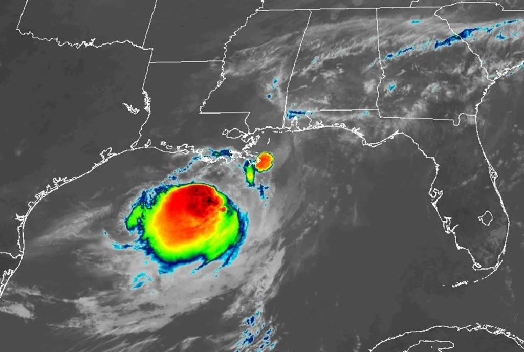
Tropical Storm Bertha, which stretches hundreds of miles, is slow-crawling across the Gulf spreading heavy rain and wind westward ahead of a coastal Louisiana landfall that poses a flood and surge threat, forecasters said.
Read more As the president touts Trump Accounts, some families are still waiting for baby’s $1,000
Beaches were closed Wednesday in the Florida Panhandle across to Mississippi.
Florida’s Panhandle has been feeling the effects of tropical storm conditions since Tuesday afternoon and could continue to see impacts through Wednesday, including heavy rain causing flash flooding, gusty winds and dangerous ocean conditions, the Florida Division of Emergency Management said in a post on X.
Bertha is likely to dump heavy rain on coastal areas of Mississippi that are still recovering from flooding brought by Tropical Storm Arthur in June that destroyed and damaged homes.
Bertha is expected to come ashore in southern Louisiana on Wednesday, then move to back over the Gulf before making a second landfall this week in southeastern Texas.
The presence of strong upper-level winds over the Gulf will likely keep the storm from strengthening significantly. But drenching rainfall would pose a greater risk to coastal communities.
“Persistent and strong winds on the backside of the circulation will push Gulf water above the normal tide levels,” Fox Weather hurricane specialist Bryan Norcross wrote on his Hurricane Intel blog.
Tropical storm watches were extended into Texas on Wednesday.
As of 11 a.m. Wednesday, Bertha was about 55 miles north-northeast of the mouth of the Mississippi River and 40 miles south of Pascagoula, Mississippi, moving west-northwest at 6 mph, according to the hurricane center.
Tropical Storm Bertha tracking map: Here’s the latest forecast path
Bertha’s maximum sustained winds have dropped to 50 mph, down from 60, with higher gusts, and tropical-storm-force winds extend up to 105 miles from the center.
Read more Terrorism trial set to open in stabbing of author Salman Rushdie
A tropical storm warning was in effect from the Okaloosa/Walton County line in Florida to Morgan City, Louisiana, and for metropolitan New Orleans and Lake Pontchartrain.
A tropical storm watch was in effect west of Morgan City, Louisiana, to Sargent, Texas, as well as Lake Maurepas. A coastal flood warning was issued by the National Weather Service for portions of the southeastern Louisiana and Mississippi coastline.
Bertha is forecast to bring between 1 to 4 inches of total rainfall through Thursday along the central Gulf Coast from western Florida to southern Texas, with isolated totals up to 6 inches, the hurricane center said.
The storm could bring 2 to 4 feet of surge from the mouth of the Mississippi River in Louisiana to the Alabama/Florida border, and 1 to 3 feet of surge along Indian Pass to Chassahowitzka, Florida; from the mouth of the Mississippi River to Morgan City, Louisiana; and along Lake Ponchartrain, according to the latest hurricane center advisory.
Weather researchers at Colorado State University recently revised their 2026 Atlantic hurricane season forecast to nine named storms, including four hurricanes and one major hurricane.
This is due, in large part, to expectations of a strong El Niño, “driving high levels of tropical Atlantic vertical wind shear” that tend to tear apart forming storms, according to the CSU report.
The next storm to form would be named Cristobal.
The height of hurricane season runs from mid-August into October. The season ends Nov. 30.
Read more Congo’s Ebola outbreak has killed nearly 1,000 people
Information from the Associated Press was used in this report.