
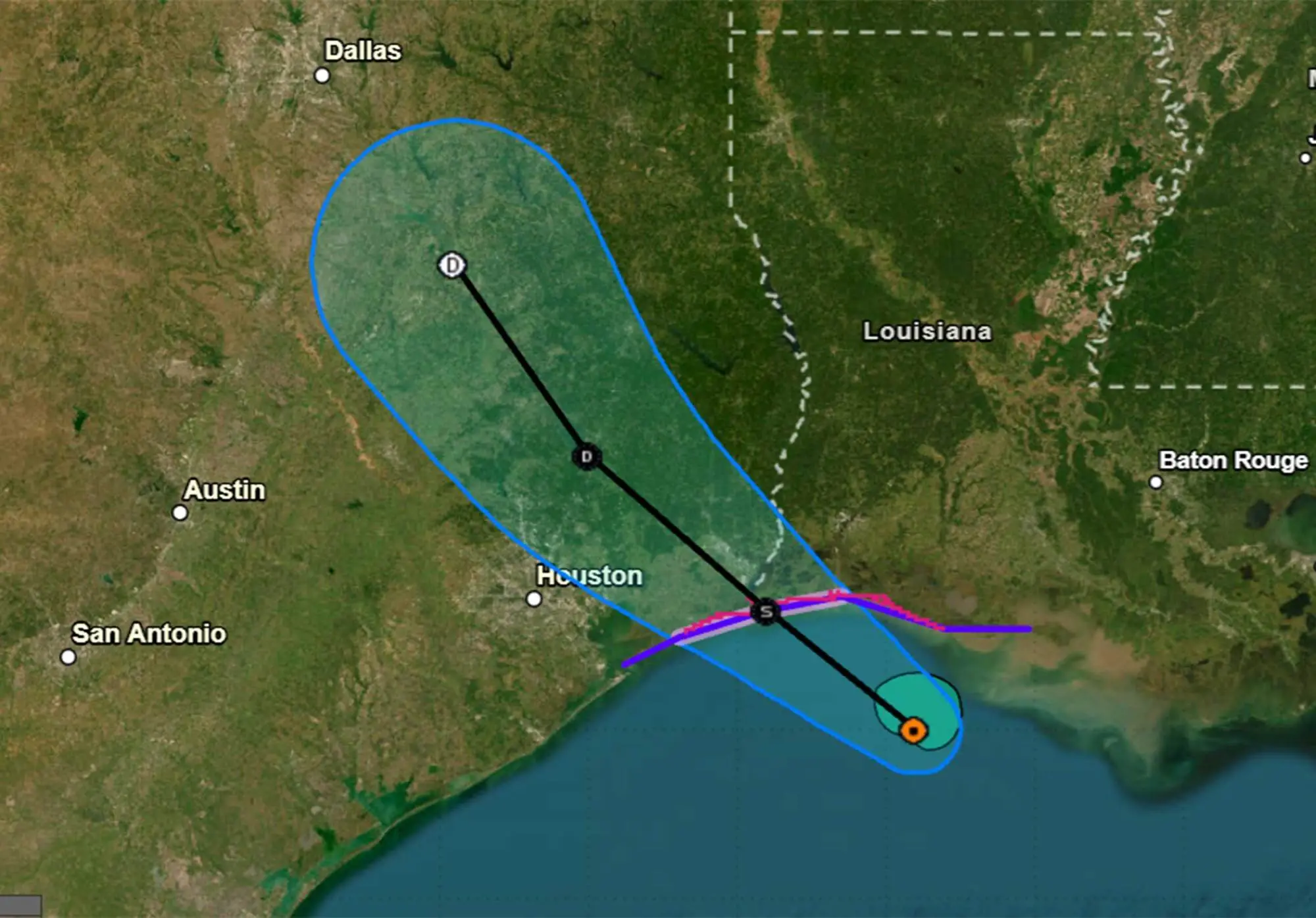
Tropical Storm Edouard formed in the Gulf on Monday night and was poised to strengthen before landfall on Tuesday while the remnants of Tropical Storm Dolly continued to make their way toward Florida, according to the National Hurricane Center.
Read more Schools reopen in Congo’s Ebola epicenter despite concerns from parents and teachers
As of the NHC’s 8 a.m. ET advisory, the center of Edouard was located was located about 40 miles south-southeast of Cameron, Louisiana, and 70 miles southeast of Port Arthur, Texas, moving west-northwest at 8 mph with maximum sustained winds of 40 mph.
“On the forecast track, the center of Edouard is forecast to reach the northwestern Gulf Coast within the warning area later today and move inland over southeast Texas tonight,” forecasters said. “Significant strengthening is forecast today and Edouard could approach hurricane strength before it reaches the northwest Gulf coast later today. Rapid weakening is expected after the center moves inland.”
A tropical storm warning was in effect for Port Bolivar, Texas, to the Vermilion/Iberia Parish line in Louisiana while a storm surge warning was in place from High Island, Texas, to the Vermilion/Cameron Parish line. A hurricane watch was also in place from High Island to Cameron, Louisiana.
Tropical-storm-force winds extend out 25 miles from its center and it’s expected to make landfall on Tuesday and bring 3-6 inches with some areas getting up to 9 inches of rain on the upper Texas coast and inland into east-central Texas. Southwest Louisiana could see 2-3 inches, and the accumulation could lead to flash and river flooding.
Edouard was no threat to Florida, but the Sunshine State could endure the remnants of what had been Dolly beginning late Wednesday and into Thursday.
The NHC stopped tracking Dolly as it had no chance to redevelop, but it’s now a surface trough of low pressure producing a disorganized area of showers and thunderstorms stretching over the Turks and Caicos and southeastern Bahamas, and headed to Florida.
“There is potential for moisture associated with the remnants of Tropical Storm Dolly to add to the soup, though it is becoming increasingly difficult to track the remnants, even the moisture plume,” said forecasters with the National Weather Service in Melbourne.
The state will already be in a state of elevated precipitation and Dolly’s remnants could mean locally high rainfall amounts of 2-3 inches with minor flooding, with some areas that could see more than 4 inches.
Read more Having issues with your limited liability company? Ask the Lawyer
The Weather Prediction Center says all of Florida would have a marginal risk for excessive rainfall on Thursday.
“Models continue to show swell from back when Dolly was a tropical storm arriving midweek, which could increase the rip current risk at the beaches,” the NWS stated.
Dolly had become the fourth named storm after tropical storms Arthur, Bertha and Cristobal.
Hurricane season began June 1 and runs through Nov. 30, but the height of hurricane season runs from mid-August through mid-October.
The National Oceanic and Atmospheric Administration earlier this month updated its seasonal forecast and now expects between seven and 13 named storms this year. Of those, two to six would become hurricanes. It also predicted that there might not be any major hurricanes this year, or at most two.
Already, 2026 was forecast to have lower-than-average storm generation, and that has been reduced even further with the latest forecasts from the NOAA and other weather groups.
An average year would see 14 named storms and seven hurricanes, with three of those growing to Category 3 strength or higher.
Read more Five-time world champ Carissa Moore to host fundraiser in Huntington Beach