
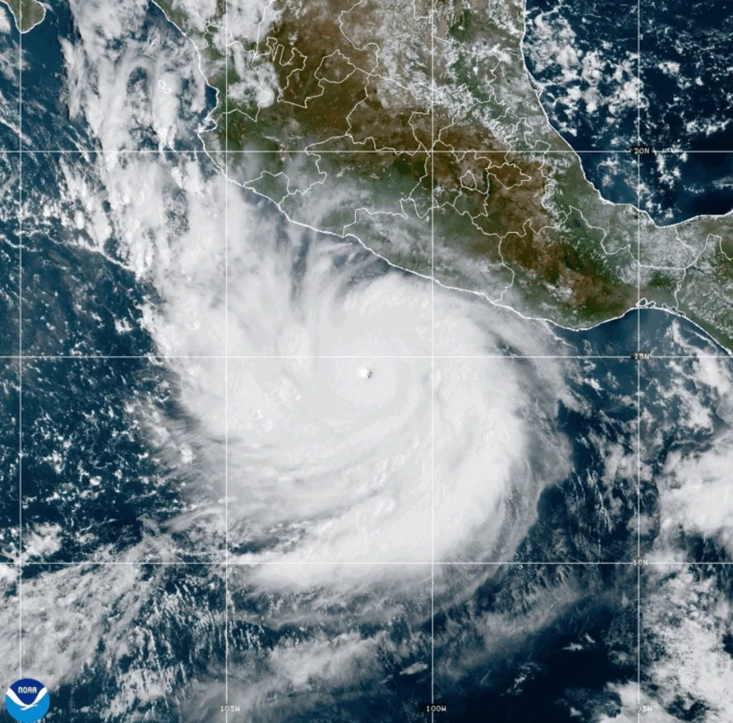
Forecasters are keeping careful watch on yet another hurricane building off Mexico’s coast that could spell trouble for Southern California’s coastline early next week.
Read more More than 160,000 pounds of meat bearing false USDA inspection labels recalled
If the direction of Hurricane Polo, called one of the most powerful Pacific cyclones in decades, holds, then it is expected to send big waves to our region as early as Sunday, Sept. 27, with the biggest waves expected on Monday. It would be coinciding with extreme high tides near 6 feet that would push waves even higher, up to a foot, experts said.
And add in a Kelvin wave — a warm-water anomaly expected to show up any time now — and even higher water levels could mean greater concern for the area’s already struggling coastline.
Another hurricane
If Hurricane Polo system shifts 100 miles to the east or west, it could mean the difference between big surf or no surf at all.
Surfline.com forecaster Kevin Wallis called it a “tricky track” forecast, with the most likely outcome an extreme-angled southeast swell early next week, Monday and into Tuesday.
But it is unlikely to be as big, or long lasting, as Hurricane Marie earlier this month, he said. And, current forecasts are not expecting rain to reach the region.
Overall, the likeliest place for potential beach flooding or further coastal erosion, during high tides, is north Orange County, though it is worth monitoring south Orange County areas as well, he said.
Forecasts show waves ramping up into the 4- to 5-foot range on Sunday and up to 6 to 8 feet at the Wedge in Newport Beach by Monday, one of the trouble areas that has suffered severe erosion since strong southerly swells started pummeling the region early this season.
Huntington Beach shows surf in the 8- to 10-foot range on Monday, down to 3 to 4 feet on Tuesday. Manhattan Beach, a south-facing beach in the South Bay, shows 4- to 5-foot waves on Monday, down to 2 or 3 feet by Tuesday.
High tide on Monday should reach about a 6-foot tide at 10:15 a.m.; about the same at about 11:15 a.m. the following day.
Hurricane Polo has already caused flooding and severe storms in Mexico, but the tropical system isn’t expected to move directly into our area, said National Weather Service meteorologist Sam Zuber.
“The only impacts we may see is erosion and coastal flooding with the swell, mixed with our typical high tides early next week,” she said.
“If you’re going swimming, be prepared for excess rip currents and elevated surf,” she said. “If you’re not a good swimmer, it may not be a good time to get into the water late this weekend and early next week.”
Ahead of Hurricane Polo, Hurricane Odalys, out in the eastern Pacific Ocean, is also expected to elevate surf heading into the weekend, with mid-range waves in the 3- to 5-foot range forecast at south-facing beaches.
Kelvin wave here
A Kelvin wave has caught the media’s attention, peppering headlines for the last several weeks. But they are actually something that happens all the time, said Andrew Leising, a research oceanographer for the National Oceanic and Atmospheric Administration.
“You can expect the sea level will be higher than it usually is,” said Leising, noting that small Kelvin pulses have already arrived along the Southern California coast. “They always happen; it just depends on what else is going on whether we pay attention or not.”
Kelvin waves aren’t so much a wave, but more of an underwater pulse traveling about 6 mph that happens when warm water sits on the ocean’s surface, causing the water to thicken.
Kelvin waves travel deep in the ocean along interfaces between surface warm water and deeper cold water. The ocean energy works its way around the equator and then up the coast toward Southern California, Leising said.
“That’s probably just reaching us now,” he said.
It’s not physically moving warm water up the coast, he explained. It’s like a whip crack that makes the ocean’s warm surface thicker.
“As that whip-cracking wave works its way up the coast, it’s thickening the top layer that is warm. That lets the whole surface area be warmer,” he said. “We can see it from a satellite; it looks like it’s moving.”
Whether it will cause damage depends on the force of the swells, and how high tides are — and if it is indeed arriving now, it will coincide with the 6-foot tides and Hurricane swell already churning up the ocean’s force.
“Worst case? It will be even worse, you’ll get more (impact),” he said of the erosion troubles and damage plaguing the region from the last hurricane remnants to sweep along the coast.
“The Kelvin wave coming — this is the big one coming in now,” Leising said. “Anytime now, any moment, it could have already gotten here. The thought is, as of today, it is just coming up from Baja.”
Once the wave comes through and disturbs the mixed layer, it can be weeks or months for conditions to rebound as colder water moves in during in the fall or spring.
On top of everything else, a marine heat wave — a massive blob of untypically warm water — has been noted along the Southern California coast this summer.
“You can have stronger hurricanes when you have warm surface water,” Leising said. “The atmosphere is super complicated and super dynamical. It’s hard to say what came first, but it’s all coupled and all related.”
Preparations underway
“I’m terrified,” said Dana Point homeowner Natalie Driessen, as she braces for yet another hurricane swell that could wreak further damage to the coastline early next week.
At least 10 homes in her Beach Road neighborhood have been red-tagged since Hurricane Maria swept through, and seven more yellow-tagged. On the Long Beach Peninsula, homes were evacuated as the heavy surf pounded the historic boardwalk and flooded residential streets — one home was yellow-tagged and the boardwalk suffered significant damage. Several oceanfront homes in Laguna Beach were also yellow-tagged.
Work continues this week to safeguard coastal areas against the ocean’s force as word — and worry — of Hurricane Polo spread.
Homeowners along the Beach Road stretch in Dana Point had crews building up rock revetments in front of their homes to protect against the sea.
“It looks like a warzone,” Driessen said of her yellow-tagged home, where a seawall of rocks was being piled in front of her cottage.
Seal Beach, where water flooded into the oceanfront parking lot and onto the boardwalk during the last hurricane swell, has built up its winter berm early, a wall of sand meant to keep the ocean’s waves away from the infrastructure and homes.
Newport Beach Lifeguard Chief Brian O’Rourke said sand berms are still in place from the last hurricane swell and pumps are ready, if needed.
“Public Works is on top of it, the city staff, we are all aware of the potential,” he said, noting that lifeguards will also staff up.
The city dispatched three more sand movers to rebuild the berm at Balboa Pier on Thursday ahead of the anticipated hurricane swell.
But hurricane systems are hard to track or predict: sometimes they change direction, other times they fizzle out, other times they intensify.
“We’re monitoring it, and a couple of possibilities show it could bring some decent surf,” O’Rourke said. “The models are pointing to it. But as far as the surf forecast, it’s uncertain for now. We’ll have to take it day-by-day. These storms are unpredictable and unstable.”