
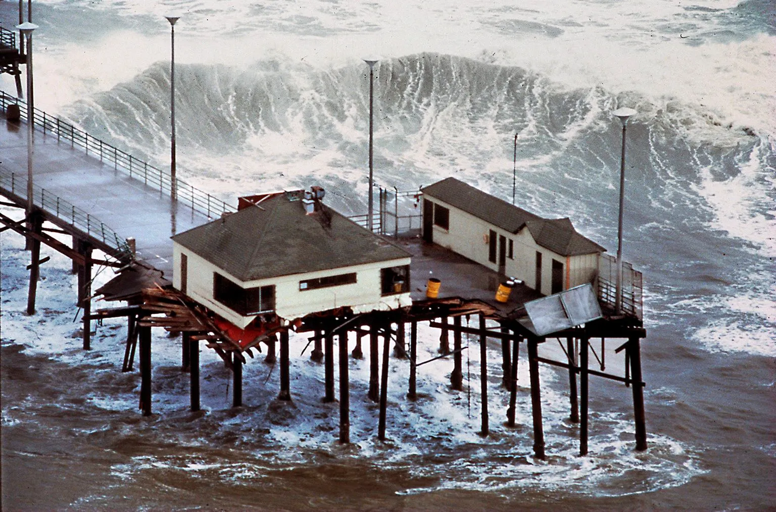
Wicked weather
The National Weather Service Climate Prediction Center is saying the chance of a wetter El Niño winter is 90%. Here’s when winter storms might do the most coastal damage.
Read more Tarik Skubal looks ready for October as Dodgers beat Giants
Hurricane Polo off the coast of Mexico and is expected to track north-northwest before it starts to turn east and eventually make landfall in Mexico. It will bring high surf to Southern California and the high tides will be near 6 feet from Sept. 26 to 31.
Very strong events
The National Oceanic and Atmospheric Association is warning that this fall and winter are likely to be very strong (up to 90% prediction), East Pacific Events: Historic “super” El Niños — such as 1982-1983 — centered in the eastern Pacific and resulted in statewide precipitation totals that were 47% to 74% above normal, often triggering severe storms, flooding, and widespread landslides.
They said, “Our understanding of El Niño and its impacts on California precipitation is limited to a small number of events — less than 30 since 1950 — with only four very strong events. Precipitation outcomes in California are driven by many factors beyond El Niño conditions.
A race against tide
On Monday, Gov. Gavin Newsom declared a state of emergency for California in order to begin preparations for severe storms.“We do not know today where every storm will hit the hardest. But we do know that we do know enough to prepare,” Cal OES Director Caroline Thomas Jacobs said.
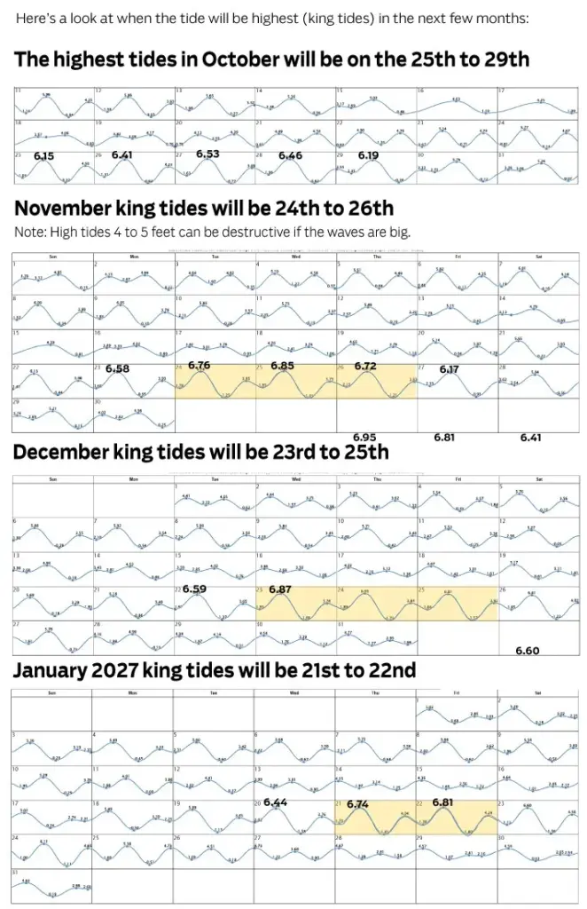
One of the biggest factors in the recent homes along south Orange County being destroyed from large waves in September was the high tides along with the storm surge. A king tide is a non-scientific, informal term for the highest predicted high tides of the year at a coastal location. Scientifically, they are known as perigean spring tides.
Wet weather
The state has had three “very strong” El Niño events since measurements were kept in 1950. These events were in 1982-83, 1997-98 and 2015-16.
The map below shows the percentage above normal precipitation for regions of the state during those very strong events up to 2010.
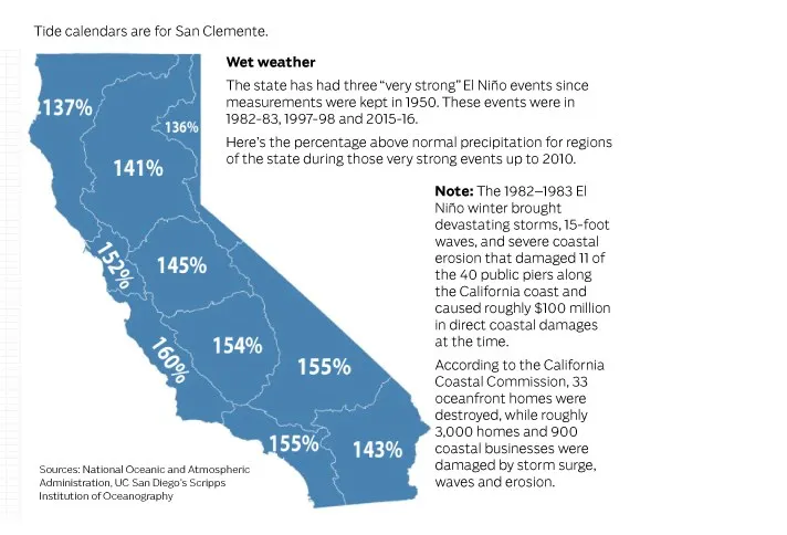
Note: The 1982–1983 El Niño winter brought devastating storms, 15-foot waves, and severe coastal erosion that damaged 11 of the 40 public piers along the California coast and caused roughly $100 million in direct coastal damages at the time
Read more At Santa Anita, trainer Aggie Ordonez seeks ‘new heights’
According to the California Coastal Commission, 33 oceanfront homes were destroyed, while roughly 3,000 homes and 900 coastal businesses were damaged by storm surge, waves and erosion.
A different kind of wave
Ocean scientists are warning about Kelvin Waves (not like a wave on the shore). Kelvin Waves are fluctuations in wind speed at the ocean surface at the equator that cause variations in the depth of the oceanic thermocline (As one descends from the surface of the ocean, the temperature remains nearly the same as it was at the surface, but at a certain depth temperature starts decreasing rapidly with depth. This boundary is called the thermocline). An El Niño-driven coastally trapped Kelvin Wave is moving up the coast toward California and is expected to arrive in Southern California by early October.
Kelvin Waves can be harmful for the following reasons:
• Higher flood baseline: The 6-inch to 1-foot boost raises the starting point for high tides, large surf and storm surges.
• Severe erosion: Combined with winter storms or astronomical king tides, the risk of significant coastal flooding, beach erosion and infrastructure damage increases greatly.
• Local vulnerability: Low-lying areas, seawalls, coastal roads and beach access points face the highest exposure.
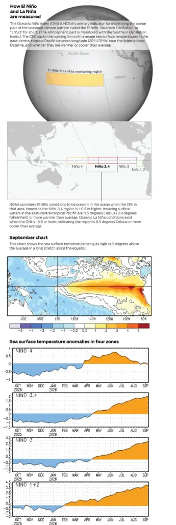
How El Niño and La Niña are measured
The Oceanic Niño Index (ONI) is NOAA’s primary indicator for monitoring the ocean part of the seasonal climate pattern called the El Niño-Southern Oscillation, or “ENSO” for short. (The atmospheric part is monitored with the Southern Oscillation Index.) The ONI tracks the running 3-month average sea surface temperatures in the east-central tropical Pacific between longitude 120°-170°W, near the International Dateline, and whether they are warmer or cooler than average.
NOAA considers El Niño conditions to be present in the ocean when the ONI in that area, known as the Niño-3.4 region, is +0.5 or higher, meaning surface waters in the east-central tropical Pacific are 0.5 degrees Celsius (0.9 degrees Fahrenheit) or more warmer than average. Oceanic La Niña conditions exist when the ONI is -0.5 or lower, indicating the region is 0.5 degrees Celsius or more cooler than average.
Sources: National Oceanic and Atmospheric Administration, UC San Diego’s Scripps Institution of Oceanography
Read more Santa Anita consensus picks for Saturday, September 26, 2026