
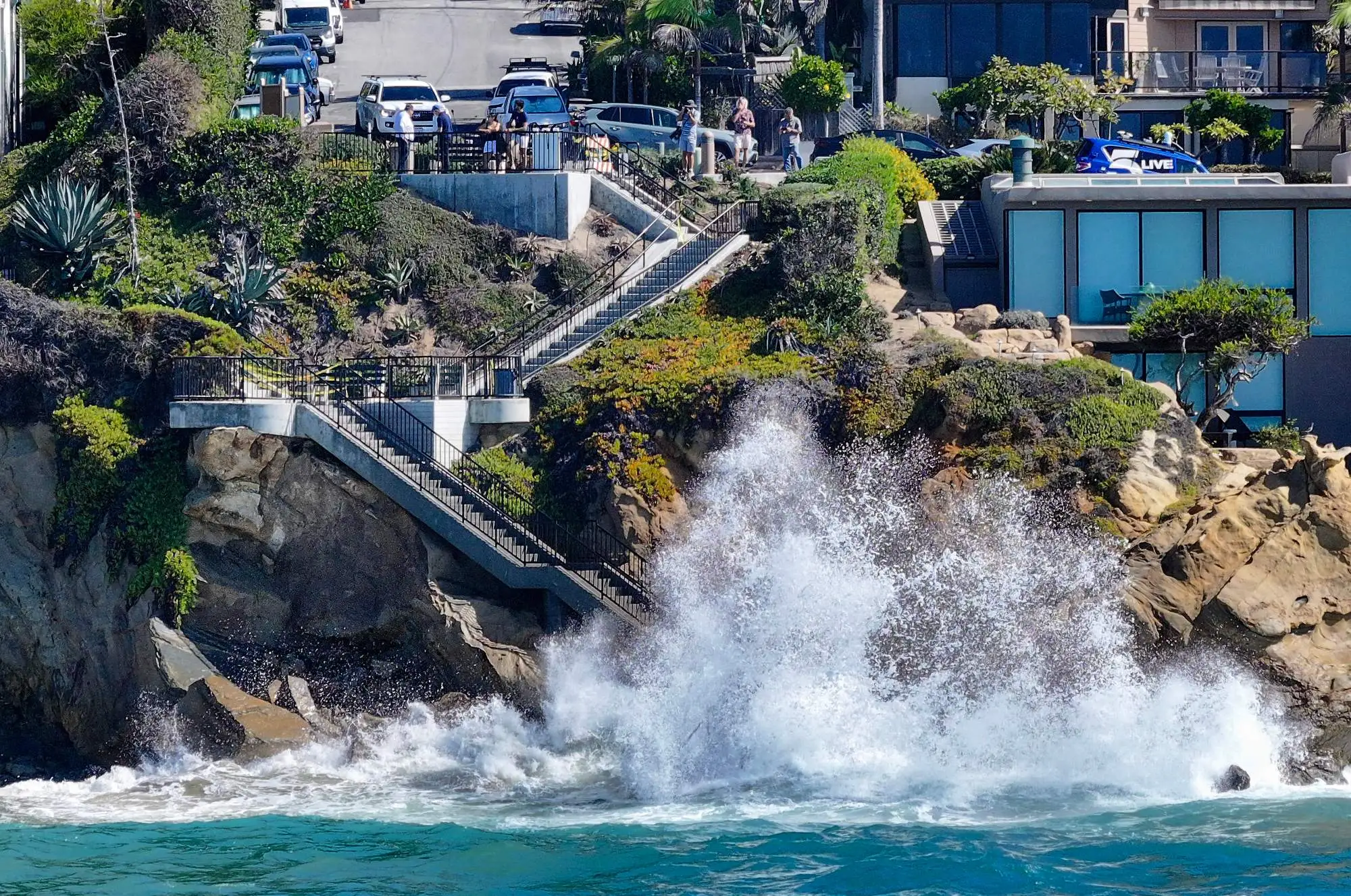
Southern California is expected to get a reprieve from its prolonged October heat wave this weekend, but the cooldown will come with widespread rain, the possibility of flash flooding in mountain communities and another round of powerful surf threatening an already battered coastline.
Read more Fryer: San Juan Hills football has an electric connection on offense
Moisture associated with Rachel, a tropical storm expected to weaken as it approaches northern Baja California, could bring moderate to occasionally heavy rainfall beginning late Saturday, Oct. 10, with showers potentially lingering through Tuesday, according to the National Weather Service.
Although the storm’s center is most likely to remain south of Southern California, forecasters said its moisture, combined with approaching low-pressure systems, could bring rain, gusty winds and significantly cooler temperatures across the region.
“The storm system right now is more likely than not to track south of the region,” said Kyle Wheeler, a meteorologist with the National Weather Service in San Diego.
In Orange, Riverside and San Bernardino counties, the heaviest rainfall is currently expected Sunday morning into the early afternoon, Wheeler said, although the timing remains uncertain. Lighter showers could continue Sunday night into Monday, with additional chances of rain through Tuesday.
Most lower-elevation areas could receive roughly half an inch to an inch of rain, while some mountain communities could see substantially more, Wheeler said.
The Santa Ana and San Bernardino mountains could receive more than an inch, with isolated areas along mountain slopes potentially seeing 2 inches or more.
Among the areas of particular concern are Wrightwood and Oak Glen, mountain communities that have previously experienced flooding and debris flows.
Wheeler said areas around the Bridge Fire burn scar could receive between half an inch to 1.5 inches of rain, with some localized mountain areas potentially exceeding 2 inches.
“It’s not a high chance of seeing flash flooding, but there is the potential,” Wheeler said.
Burn scars are particularly susceptible to flooding and debris flows because fire-damaged terrain can shed water rapidly during heavy rainfall with out healthy vegetation to hold things in place.
• Also see: Warnings, dam cleanouts, ‘preparing for the worst,’ if El Niño sends storms to Eaton fire burn zone
The concern isn’t limited to burn areas.
“Anywhere in the mountains — really, anywhere in the region — there is at least a marginal risk for flash flooding this weekend,” Wheeler said.
The storm’s exact track remains a significant source of uncertainty.
Although most forecast models favor Rachel moving into northern Baja California, some show a farther-north path toward Southern California, according to the National Weather Service’s Thursday afternoon forecast discussion.
Such a shift could bring heavier rainfall and stronger winds to the region, particularly Orange and San Diego counties.
Wheeler said a less likely track closer to San Diego or directly over Southern California could produce higher rainfall totals and additional wind impacts.
As of Thursday morning, tropical storm-force winds were not expected inland, though gusts of 20 to 35 mph are possible in valleys, primarily on Sunday.
Los Angeles County is also expected to receive rain, although the latest forecast favors lighter amounts.
Los Angeles County could receive between a quarter-inch to three-quarters of an inch of rain, with locally higher amounts up to 2 inches in the San Gabriel Mountains, National Weather Service meteorologist Devin Black said.
Additional showers are possible Monday as another low-pressure system moves into Southern California.
Black said there was a 70% to 90% chance of intermittent showers between Saturday night and Tuesday, with the highest chances Sunday morning and Monday evening. Peak rainfall rates were generally expected to remain at or below a quarter-inch per hour, although thunderstorms could produce heavier downpours, he said.
The chance of thunderstorms is relatively low, around 5% to 10%, with the greatest possibility Monday, Black said.
Winds of 20 to 30 mph are possible from Saturday through Monday, with gusts reaching 30 to 35 mph in some areas. The strongest winds are expected in the Antelope Valley.
The approaching weather will also bring a dramatic drop in temperatures after the prolonged stretch of unusually hot October weather.
High temperatures across much of Orange County and the Inland Empire are expected to fall into the 70s by Sunday, with some Inland Empire communities potentially remaining in the 60s throughout Monday, Wheeler said.
Monday is also expected to be the coolest day in Los Angeles County, Black said. Inland LA-area temperatures could fall 15 to 20 degrees below normal for this time of year, while downtown Los Angeles could run 10 to 15 degrees below normal.
Highs across much of the county are expected to settle into the upper 60s and 70s.
Read more City of Hope Breast Cancer Awareness Month event celebrates ‘strength and resilience’
While inland communities prepare for rain, Southern California’s coastline is bracing for another round of high surf and flooding, adding to weeks of swells, erosion and unusually high water.
The National Weather Service has issued coastal flood advisories through 2 p.m. Tuesday, warning of minor to locally moderate flooding in low-lying areas, particularly around high tides.
The greatest risk is expected Sunday, when elevated surf and unusually high water levels could send seawater spilling into beach parking lots, across bike paths and harbor walkways and into streets. The daytime high tide hits around 9:45 a.m.
• Also see: Here are some dates that could be very destructive with high tides and El Niño in California
High tides on Friday and Saturday in the mid-morning are inching near 6 feet, while a night high tide after 9 p.m., is expected to be around 5 feet and could also lead to flooding.
Forecasters in Los Angeles are particularly concerned about flooding in Long Beach, where previous heavy surf events have already left vulnerable areas susceptible to additional damage. The peninsula’s boardwalk was damaged during Hurricane Marie and homes were threatened with flooding.
In Newport Beach, utility crews have spent recent evenings running pumps along the Balboa Peninsula and on Balboa Island to keep water at bay and plan to continue through the weekend and into Monday if rain persists, city spokesperson Georgia Rios said.
Berms are also being reinforced, and 40 to 50 city employees are expected to work each day over the weekend to respond to flooding or other problems.
“We’ll monitor the rain, but we typically see flooding on the peninsula and island in low-lying areas,” Rios said.
In Laguna Beach, waves arrived about 2 feet higher than expected Thursday, with surf around 5 feet, Marine Safety Chief Kai Bond said.
Minor flooding was reported around Pacific Coast Highway on Thursday, and officials were monitoring several vulnerable stretches of beaches, roads and coastal properties.
“It’s really hard to tell what’s what at this point, the specific cause of it,” Bond said. “We have three things going: surf a little larger than normal, high tides, and then potentially the effects of the Kelvin wave.”
A Kelvin wave is a warm-water anomaly that travels from around the equator and pushes water levels higher for extended periods.
• Also see: What is a Kelvin wave, what does it have to do with El Niño, and should we be worried?
A portion of Aliso Beach and its parking lot remain closed, as do the Agate Street stairs, where a recent rockslide raised concerns about the structure’s stability. Officials are also monitoring Pearl Street beach and the area near Victoria Beach.
“There’s just a bunch of areas we’re continuing to monitor; none of them have seen significant damage,” Bond said.
San Onofre Surf Beach’s lower lot access was closed on Thursday, following road damage from high tides and heavy surf. The lower dirt lot will be closed until further notice, and the upper paved lot will be temporarily closed on Friday while crews assess the damage, according to State Parks.
The beach remains open to surfing, biking and walking, but pedestrian and bike access will be restricted on Friday.
Waves could reach 8 to 10 feet at some Orange County beaches Sunday, according to Huntington Beach-based forecasting site Surfline, potentially worsening coastal flooding and erosion as Rachel moves toward the region.
Surfside communities along Pacific Coast Highway near Huntington Harbour are also a vulnerable area when seawater floods into streets and into homes.
Areas that have already seen homes battered during relentless summer tropical swells are bracing for more damage, with seven homes still red-tagged in Dana Point along Beach Road, and others being watched carefully in Laguna Beach near Victoria Beach. Two homes in the Beach Road community have already been demolished because of damage, and another is expected to be soon. Another dozen are yellow-tagged.
“All city departments, in coordination with emergency management, are prepared to respond to significant storm events,” spokesperson Jessica Spaulding said in an email. “The city will monitor weather conditions, coordinate with its agency partners, and take appropriate action to protect the community and maintain essential services.”
Huntington Beach is offering its residents free sand and sandbags at the Edison Community Center, Warner Fire Station and the city’s Corporate Yard in preparation for wetter weather and rising sea levels.
“Sandbags can help divert water away from doorways, garages, and other low-lying areas, but they work best when you’re prepared before the rain arrives,” officials said in an announcement.
Officials urged residents to plan ahead, drive cautiously and never attempt to drive through flooded intersections.
Read more 400+ Orange County workers set to strike Tuesday if new contract not reached