The swell that brought massive waves to Southern California beaches midweek is easing slightly into the weekend, but conditions will still be dangerous — and more strong surf is lining up for next week.
Read more Fire destroys medical equipment warehouse in California and prompts evacuations at nearby facilities
Though waves peaked Wednesday, June 10, and were starting to slow down Thursday, a beach advisory is still in place, said Lauren Villasane, meteorologist for the National Weather Service.
Friday’s surf is expected to be in the 3- to 6-foot range, a bit higher in areas such as Huntington Beach and the Wedge in Newport Beach. The waves are expected to drop Saturday to about 3-5 feet, with sets up to 6 feet.
“We will still have high rip current risk, so definitely be conscious of the safety conditions there, pay attention to flags and signs,” Villasane said. “Definitely take precautions this week going to the beach.”
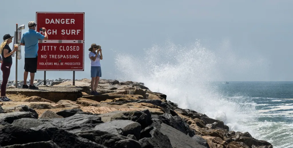
An annual swim around the Huntington Beach Pier, scheduled to celebrate its 75th year on Saturday, has been canceled due to high surf. The new date is Aug. 29.
Huntington Beach Marine Safety Chief Trevor McDonald said staffers this week are focused on preventative rescues, with some rip currents pulling hundreds of yards offshore.
From Tuesday until about 1 p.m. Thursday, Huntington Beach lifeguards made 24 rescues and 764 preventative actions, notifying people attempting to go in the ocean who maybe didn’t know how dangerous it was, he said.
“We want to prevent the rescues; the rescues we are making are critical. People are exhausted, they are getting pulled offshore,” he said. “The best measure is to educate the public about how dangerous it is. We advise them to just wait until the ocean conditions can calm down, pick another day when it will be safer to recreate. Right now, it’s just not safe.”
But when it will be safe is unknown.
While waves will slightly dip Saturday, surf will be back up to the 6- to 8-foot range Sunday and Monday, with big, consistent surf all next week, McDonald said.
Read more 3 arrested after violent home invasion robbery at Newport Beach home
“We anticipate strong, elevated surf conditions for the significant future,” he said. Significant swell is showing up on the models for the next two weeks.
“We continue to monitor the swell every day,” he said. “We will absolutely be taking preventive measures all the way through the swell event, or all through summer. Whether the waves are big or small, we don’t want people coming to the beach and having that near-death experience. We want people to come to the beach and have an exceptional time at the beach.”
Surf breaks, especially near the pier on the outside break, can be deceiving, he added. “People get out here and realize they are over their heads; their ability is not quite up for just how hazardous the large surf and water movement and rip currents can be.”
There is an unusual marine heat wave that has been spreading up the coast and an expected El Niño later this year, creating weather patterns that may keep lifeguards nonstop busy, with more ocean storm activity than normal.
“The warmer water allows more moisture above the water, and allows more storms to go through,” said Andrew Leising, research oceanographer for the National Oceanic and Atmospheric Administration. “It could set the stage for stronger water events.”
When water warms, it expands, meaning the ocean levels become higher. Tides get higher, and the ocean height increases during El Niño, he said.
“El Niño warms to a much deeper depth along the coast. The water expands and is higher along the coast. (Take) whatever storms you do have and put them on top of that — it will be more impactful when you have those waves coming up on the beach,” Leising said.
That could spell big trouble for erosion at the beach. Also, kelp beds, which act as a barrier between the ocean and sandy beaches, could also be impacted, he noted.
Read more Christian Pulisic is ready to shoulder the burden of US hopes in home World Cup opener vs. Paraguay